


| Ottawa Airport 613-248-2125 Fly in - rent a car, you're here in 1 hour. |
 |
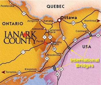
| Driving Time To Perth From | |
| Ottawa | 60 minutes |
| Kanata | 45 minutes |
| Hull, Quebec | 65 minutes |
| Kingston | 60 minutes |
| Gananoque | 55 minutes |
| Brockville | 50 minutes |
| Clayton, NY | 80 minutes |
| Watertown, Ny | 90 minutes |
| Rochester, NY | 4 hours |
| Toronto | 3 hours |
 By Boat: You can also reach Perth via the Rideau-Tay Canal System. The Tay River branches from the Rideau Canal between Smiths Falls and Newboro. There are two locks (#33 Lower Beveridges, #34 Upper Beveridges) which bypass the river to join Perth to the main canal. Parks Canada operates the canal seasonally, late May to Thanksgiving.

